
Long before paved avenues, urban sprawl, and modern irrigation canals defined the southern San Joaquin Valley, the landscape surrounding present-day Kern County was a vast expanse of open grasslands, oak groves, and unpredictable marshlands. To survive in this harsh yet fertile environment, the mid-19th-century homesteaders who arrived along the banks of the Kern River had to rely entirely on local resources. Understanding Bakersfield pioneer era history begins with mapping the earliest adobe homes—the humble, hand-built structures that sheltered the region’s founding families and laid the foundation for a permanent community.
The Tule Reed Marshes and the Kern River Delta
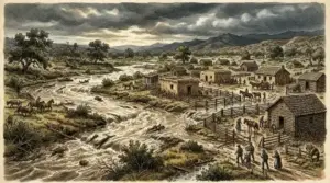
During the 1850s and 1860s, the geography of the southern San Joaquin Valley was dominated by the shifting courses of the Kern River. Prior to wide-scale agricultural diversion, the river emptied into vast shallow basins, creating lush tule marshes known to early travelers as “Kern Island.” While the land offered abundant game, natural grazing pasture, and fertile soil, it also presented severe environmental challenges. Summer temperatures regularly soared past one hundred degrees, while winter rains brought treacherous mud and sudden water shifts.
Pioneers migrating toward the valley after the California Gold Rush recognized the agricultural potential of the region, but building permanent shelter required ingenuity. Traditional timber was scarce on the flat valley floor, and importing milled lumber across mountains by horse-drawn wagons was prohibitively expensive. To adapt, early homesteaders adopted time-tested construction techniques perfected over centuries in the American Southwest and Spanish Alta California: adobe mud bricks.
Architecture of Survival: Crafting Sun-Dried Adobe
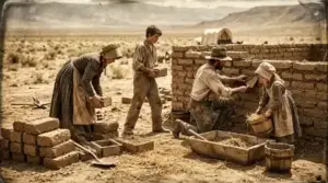
Building an adobe home required patience, physical stamina, and a deep understanding of local materials. Settlers harvested rich clay soil directly from riverbank deposits, mixing it with water, chopped wild straw, and native tule grasses to act as a binding binder. This heavy mixture was hand-packed into rectangular wooden molds and left to cure under the scorching valley sun for weeks until solid.
The resulting bricks were stacked into massive exterior walls, often eighteen inches to two feet thick. These thick earth walls acted as exceptional thermal mass, absorbing the oppressive heat of the afternoon and keeping interior living quarters remarkably cool. During chilly winter nights, the stored thermal energy radiated inward, offering natural climate control long before modern building systems existed.
Roofing was similarly constructed from available resources. Early builders framed roof structures using sturdy local willow or oak timbers, covering them with layered tule reeds and a protective coat of packed mud. As settlers prospered, these earthen roofs were often replaced with wooden shakes or tin to better withstand winter downpours.
Tracing the Earliest Family Homesteads
Mapping these initial structures reveals how early settlement patterns naturally mirrored the flow of water and access to natural pastures. Long before Colonel Thomas Baker arrived in 1863 to drain marshlands and establish his famous alfalfa field—known locally as “Baker’s Field”—individual ranchers and homesteaders were already establishing roots throughout the area.
Families like the Kerns, the Landsfords, and early Hispanic landholders utilized natural high points near river crossings to construct their homesteads. These adobe homes served as multi-purpose hubs. Beyond functioning as private family residences, they frequently operated as informal waystations for weary travelers journeying between Los Angeles, the Stockton mining hubs, and the mountain mining camps of Havilah.
Inside these homes, life was sparse but functional. Packed earth floors were meticulously swept and sometimes hardened with ox blood or oil. Small, deeply set windows minimized direct sunlight while allowing cross-breezes. Simple iron stoves, wooden trestle tables, and hand-carved benches populated the living space, reflecting a self-reliant lifestyle driven by necessity.
Surviving the Elements: Floods, Fires, and Rebuilding
Life in an adobe home along the Kern River was not without risk. The greatest threat to these earthen structures was uncontained water. While adobe bricks were exceptionally durable in dry weather, prolonged exposure to heavy moisture could melt unrendered mud walls back into the soil from which they came.
Great floods—most notably the devastating California flood of 1861–1862—transformed the entire valley basin into an inland sea. Swollen river currents swept across Kern Island, eroding foundation walls and washing away early farmsteads. Pioneers who survived these events learned to construct higher stone or cobblestone foundations beneath their adobe walls, elevating the mud bricks above surface floodwaters.
Fire was another constant hazard, particularly during dry autumn months when wild brush fires swept across the valley floor. Here, the non-combustible nature of adobe walls provided superior protection compared to wood-framed structures, allowing many early homes to withstand wildfires that cleared surrounding vegetation.
The Legacy of Bakersfield’s First Neighborhoods
As the settlement expanded through the late 1860s and 1870s, the landscape gradually shifted. The arrival of regional rail connections and mechanized brick kilns introduced red fired brick and imported lumber to the local building market. Frame houses and Victorian architecture quickly eclipsed traditional adobe construction as symbols of modern progress and economic prosperity.
Over time, many original adobe homes fell into disrepair or were demolished to make way for commercial agricultural fields, civic expansion, and urban infrastructure. However, historical mapping, land deeds, and archaeological surveys continue to reveal the precise footprints of these original dwellings along historical river channels.
Today, studying the distribution of Bakersfield’s earliest adobe homes offers invaluable insight into how human determination, environmental adaptation, and natural geography intersected. These pioneer structures were far more than temporary shelters—they were the physical anchors that transformed a wild river delta into a resilient, thriving community.
Preserving Regional Pioneer Heritage
Understanding the architectural ingenuity of early homesteaders encourages a deeper appreciation for the rich history buried beneath modern streets. Local historical societies, museum archives, and historical markers throughout Kern County continue to document the stories of the families who built their lives from the very soil of the valley floor.
For research, historical archives, and detailed regional records on California’s settlement history, historians often consult external educational resources such as the Library of Congress for historical land maps, or explore regional collections documented through the California Historical Society.
By mapping and honoring these early physical structures, we ensure that the courage, resourcefulness, and foundational heritage of Bakersfield’s pioneer era remain an active part of our collective memory for generations to come.